Hi, Friends! I haven't blogged in awhile. I made a change in grade levels from 1st to 3rd and that has taken up all of my time these last 2 years. Now that it's summer, I am excited to start sharing the awesome fun my teammate and I have been creating for our kiddos while they are learning. The first project I created after moving to 3rd was a 7 continents geography project. I knew our standard was to teach students to use political and physical maps, but that seemed so boring! I wanted to make something Arts and Project-Based to be fun, yet rigorous, and hit all the mapping and geography standards. They would create the continents out of salt dough!
We started by reviewing how to read maps, use compasses and to tell the difference between physical and political maps. We also learned about landforms and practiced landform vocabulary. After a week of mapping and geography skills, students were split into groups and picked one of the 7 continents to research. I did not have anyone chose Antarctica as there aren't enough political or physical features for this project. I did model with Antarctica though, so they could learn about it.
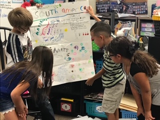
Now that they had their continent chosen, it was time to study the physical landforms and bodies of water that make up and surround their continent using many different maps as references.
While students studied their physical maps, they created their own on a large 11 x 17 blackline as a group. This 2-D physical map becomes the "plan" for their 3-D model out of salt dough.
After everyone completes their physical map, it's time to make SALT DOUGH continents. They are having so much fun they don't even realize they are continuously referring back to their map to create their continent!!
You can see this group's 2-D physical map as they create their salt dough continent.
Once the salt dough has dried, it's time to paint. Now we can tell what all of those landforms are!
After the salt dough project, we are far from done. The group will now work together to make a large political map on another 11x17 blackline. Using the political maps I copied for them.
Each group has their physical and political maps done and now they are invested in their continent so it's a great time to integrate Language Arts with research and writing about one of the 7 continents. Each group has books on the continents and we use Epic books to take notes. The note page follows the same headings as in the Bobbie Kalman books on Epic. I also ordered some used versions to have since I'm not 1:1 computers.

Lastly, groups research, write paragraphs and then create a presentation to share their learning with the class.
If you're interested in this project and using any of the resources mentioned, plus rubrics for the teacher as well as student rubrics, click the picture below.
Have fun mapping the 7 continents!


 7 Continents - Having Fun with the Arts, Maps and Geography


ReplyDeleteشركة تنظيف بعنيزة
شركة تنظيف خزانات بعنيزة
شركة مكافحة حشرات بعنيزة
شركة نقل عفش بعنيزة
شركة تنظيف منازل بعنيزة
شركة رش مبيدات بعنيزة
شركة فرسان القصيم
Great celebrity birthdays
ReplyDeleteGreaat post thankyou
ReplyDelete